
A Hike Which Changed My Life
Park to Park
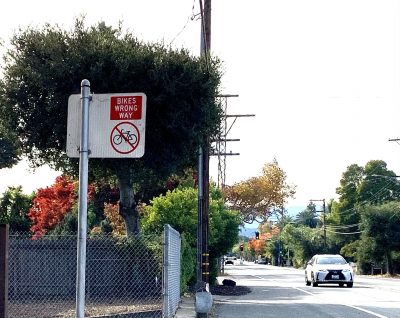
In an ideal world, each section of our Hike to the Ridge would start and end at a city park until we reached the hills and real trails. Today, we planned to walk from Cooper Park to Heritage Oaks Park but CMT means always being ready for things to take longer than they should.
I’m going to intersperse today’s hike with memories of a hike a few years ago when I failed to take that into account. I’m still living with the results of that hike.
That Fateful Hike Three Years Ago
I’d just finished telling stories to kids at a summer day camp. (I’m also a professional storyteller.) It was in Castle Rock Regional Park in the foothills of Mount Diablo and it seemed a shame to just get in my car and drive home.
So I waved goodbye to the kids and headed deeper into the park for a nice, small loop. I’d just discovered that Google Maps included hiking trails. My phone said that in half a mile a right fork would lead along the hillside above the picnic area where I told stories. I could wave to the kids and in another quarter mile, reach a brief descent to the parking lot. Safe. Easy.
But when I got to the turnoff for that hillside trail it was blocked by a striped sandwich board with an askew brown sign saying, “Trail closed.”
No problem. Google Maps showed another junction in a quarter mile. I walked on, about to get into trouble because I didn’t want to turn back.
Present: Walk Along Levin
Geri and I left Cooper Park and we walked along quiet streets through a plush neighborhood. I wish everyone in the world could live this comfortably.
As I write this, facemasks are required whenever you step out of your house but when we did the hike they were only recommended. So I had a facemask but wore it only when a jogger hove panting into view. A hike without all the scents is just physical exertion.
We turned onto a street called Levin. My stuffed-attic mind thought of Anna Karenina and how my mother had once said, “Levin has nothing to do with the main story. He’s just in there because Tolstoy was writing himself into the book.” I’d never read the book but I parroted that remark at college in the middle of a class discussion about some other book. After class, the teacher called me over. “I don’t agree with you about Levin,” he said, inviting discussion.
I blushed and hastily left.
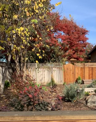
We passed more native plant gardens, dry and stately, and gardens with roses that smelled like cinnamon or spiced peach. Behind the houses on our left, the map showed a little stream but we couldn’t get a glimpse of it through any side yard. How lucky these people were to have a stream in their back yard, I thought. But I changed that opinion when we finally saw the “stream.”
Three Years Ago: The Fairy Lantern Trail
The next junction had a sign that said “Fairy Lantern Trail.”
Now how could I resist a trail with that name? It went up a beautiful valley; nothing spectacular, just quiet, soberly lovely rock formations and low graceful dusty trees. It was sort of fairy-like but also like something out of Ursula LeGuin’s Always Coming Home.
But it kept climbing; it couldn’t be the easy hillside trail to the parking lot.
No problem. I’d just do a bigger loop: according to the map, if I took the right fork at the next four junctions, I’d do a loop three times longer but no harder.
So I kept going.
First right and a gentle climb. 2nd right and another gentle climb. Halfway through the loop now and getting extra exercise. Yay!
Third right. Hmmm, a little steeper. I wouldn’t want to go down this, I thought. The steeper the downhill, the harder on my feet and weak legs. Guess I’m committed to finishing this loop.
A sharp elbow with a sweeping view of Mt. Diablo. Level ground ahead but the third junction and the gentle descent was out of sight around a curve behind the trees. I walked forward and rounded the curve.
When Lewis and Clark were halfway through their journey, they crested a hill, expecting to see before them a gentle descent to the Pacific Ocean. Instead they saw the Rocky Mountains.
The trail didn’t curve to the right and descend. It surged up the hillside like a painted ribbon.
Present: That “Sweet Little Stream”
Geri and I reached a little cul de sac with a turn-around and a narrow passage like an afterthought just wide enough for a car, out to the main road again. Eagerly we turned left on Grant to a bridge over that little stream.
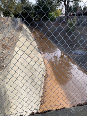
A cement canal with dirty sludge filling it, an eyesore. The people in that line of houses must hate to look out their back windows. I read later that the canal is an overflow to prevent flooding on Permanente Creek, a block to the north.
Our way lay along the busy four-lane for a block. I avoided walking on the gravel and walked in the bike lane instead. I’m more likely to slip on gravel.
Then right onto a tiny street where we saw a sign that horrified me for an instant. “No black school dropoff.”
It couldn’t mean what it sounded like, not in Mountain View, CA, not in this day and age. (I wish I could say “not anywhere, any time.”) A quick check of the map showed that one block down on the right was Georgina P. Blach Middle School. Look at the sign again. “No Blach School dropoff.” Uh, yeah. Blush.
Three Years Ago: Climbing into Danger
Of course when I saw that ribbon to the sky I should have turned back and struggled down the moderate hill I’d just climbed. But I was two thirds of the way through the loop. I climbed and hoped.
The hill was so steep that with my poor balance I nearly toppled backwards from the pull of my daypack. I struggled on, keeping my eyes on the few feet of dirt and rock ahead. At last I crested the monster.
And found myself at the foot of another surge.
I looked despairingly at the fire road climbing what seemed like a wall. But with a guaranteed horrible descent if I turned back, I sweated up that final rise to (at last) a level stretch along a ridge.
Any moment I’d see the downhill trail. Like it was the morning of a test I hadn’t studied for, I chanted maybe it will be ok, maybe the slope down will be gentle…
I came to the final right turn where the trail to the parking lot cut off.
It hung from the ridge trail like a ribbon draped over a crossbar, plunging so fast that it was lost to sight in a few feet.
Present: Adjusting Expectations
Even walking flat city sidewalks with CMT, I can do less than I think. Heritage Oaks park was only about five blocks away but we didn’t have time to reach it.
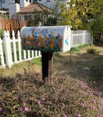
So we stopped under soft shady trees, across the street from mailbox painted with oak leaves and vines. The owner was in his yard, a youngish man. I called out, “I love how you’ve painted your mailbox!” He smiled. “There’s some other nice mailboxes down that street,” he said, pointing. Friendly encounters mean even more when you have to wear masks.
We took a different route back and stopped in a tiny park. You remember in Geometry when you had to draw three lines that intersect in one point and you invariably found you’d drawn a small triangle? That’s how three streets met to make this tiny park. There was an inviting bench but this was still early days of COVID and we didn’t know how careful you had to be not to touch any surfaces. We spread trash bags to sit on. Peaceful, berries growing, birds singing. Warm sunny day with nothing to worry about and a nice walk for next time.

Three Years Ago: What to Do?
I looked at the trail plummeting steeper than a roller coaster (it seemed) and thought about the ordeal ahead. Half an hour of struggle would inch me down a few hundred feet until I’d have to sit, exhausted. Then I’d struggle up and lurch on, not enjoying the scenery, every nerve screaming, trying to watch for loose gravel or uneven rock but never able to see the one pebble which would shoot my foot forward so I slid down a knife edge and slammed my knee bloody. And I’d reach my car an hour after dark. If I was lucky.
But I did have one other option.
To be continued…