
(Memories of the Tooth’s First Bite)
Calling in the Past, Hiking On
There was something I hadn’t told Geri yet as we stood together in Bubb Park a week after our first hike.
“So there’s something I always do,” I smiled sheepishly, “when I start the next section of a big hike. I like to put my feet right where I left off last time and, kind of, join with last week’s self? So it feels like one continuous hike.”
She nodded with amused delight. “Let’s do it.”
Perfect response. Amusement, but no eye rolling or exaggerated patience. She knows I’m quirky but it delights her.
We walked to the spot where last week we’d left the paved path to sit on the grass and watch plump squirrels running along a fence. “Is this where we were?” she asked. “I didn’t track it.”
“Well,” I admitted, “I didn’t mark it exactly either. It’s more a spiritual sort of thing, joining this hike to last week’s hike.”
“Got it.”
We stood where I imagined our feet were a week ago and she took my hand. “So,” I said, “I remember leaving our door and walking through the courtyard and down the street and past Hans and Gretel and past the school and we came into Bubb Park and reached this spot. And now I pick up our selves of last week and we carry the hike further.”
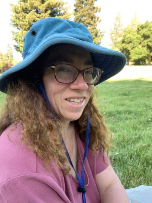
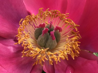
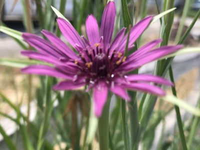
She lifted an eyebrow: ritual complete? I nodded and we started forward on the paved path through Bubb Park, Geri taking pictures of flowers as we walked. The little details she notices help me appreciate them more.
“You know, picking up each week’s hike so it’s one continuum,” I said, “that was how I hiked the whole Bay Area Ridge Trail back before I met you.”
Big Projects
One reason I’m telling you about this hike now is that my dad keeps urging me to write about that Bay Area Ridge Trail hike. “You’re an inspiration, the way you get out week after week and don’t let your disability hold you back,” he tells me. “You should write a book about your hike.”
I’m a little compulsive, in case I’ve been too subtle about that. I like to take on big “do it completely” projects. Among the things I’ve done over the years, I include:
- Listening to every Beethoven piece in Opus number order
- Reading every science essay Isaac Asimov wrote for The Magazine of Fantasy and Science Fiction in the order that he published them. I even ordered back issues of the magazine to get ones that were never published in a book.
- Listening to the recording of every Feynman lecture in the order they were originally given, just like I was “taking the class.” I even made my own recordings of missing audio – I wanted to hear another Feynman lecture so bad I didn’t care if I had to record it myself!
And of course, hiking every completed section of the Bay Area Ridge Trail.
Bay Area Ridge Trail
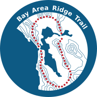
If it’s ever completed the Bay Area Ridge Trail will be a vast 500+ mile loop around the San Francisco Bay, reaching north to Mount Saint Helena and south as far as Gilroy. They’ve got about 380 miles completed but the last couple hundred miles are on private land and who knows if they’ll ever be blazed.
Between 2002 and 2008 I hiked every completed segment. Where the trail had big gaps I drove the nearest road, gazing longingly at the hills and imagining my feet walking every step. And with every hike, I’d “pick up” all the others, standing where my feet stood last hike or at whatever gate marked the start or end of a gap.
When I started that 5.5-year project I was still strong. I’d had the CMT diagnosis for years and I’d had to swallow the bitter pill that I couldn’t backpack anymore but as long as I carried only a daypack, I could handle steep hills without pain.
That changed in one day. I remember the moment.
First Falls

I’d just finished Two to Conquer by Marion Zimmer Bradley and though it wasn’t the last Darkover book she wrote, it was the last one I hadn’t read yet. I’d cherished those books and closing the back cover on the last “new” one as I sat by a little pond felt like closing a chapter in my life. I put the used paperback in my daypack and walked on up the MacDonald Trail to a flat section at the top of a ridge, with no hint in my peace-filled soul of how my life was about to change.
Was there a puddle or the tiniest dip in the fire road? I can’t remember. All I knew was my right foot skidded out from under me. I fell hard on my left knee and my hands, all the breath thumped out of me.
I knelt there, knee throbbing, palms stinging, trying to understand how I had fallen. Slowly, heart pounding, I got to my feet again and walked on, shaken.
A few hundred yards farther on I fell again. This time the fire road was plunging steeply down to Redwood Road. My downhill foot skidded on a loose bit of gravel and I fell on that same knee. I’ve never been tough and stoic: I screamed, “Yaa-aaahhhh!” as I fell.
I’m also way more superstitious than I like to admit. Two identical falls in five minutes felt like a warning. I had moved into a new chapter of my life.
When I got to my feet I was shaking. And suddenly, that steep downhill was the hardest thing I’d ever done. I was so afraid of falling again that I practically inched down it.
Several hundred feet further on, I fell again.
Somehow I made it down that steep stretch. When I easily retraced my steps back up, I couldn’t believe how hard the downhill had been.
But after that day downhill stretches, which used to be the reward for making it to the top of a steep hill, became an endless agony of trembling legs and aching calf and thigh muscles. How could things have changed so much in one day?
At the time, not wanting to accept that my hiking was forever changed, I wondered if that section of trail had looser gravel or different soil? Maybe summer had dried the dirt just enough so that it crumbled – but downhills in summer had never been hard before.
I now think those three falls in a row shattered my confidence, made me walk with cautious tightness in terror of falling again. I didn’t actually fall often after that one day which established the new norm in my superstitious soul but weeks of anguished care would always end with a slither and a shrill of electric horror and a bruised or gashed knee.
For a while my hikes became so miserably slow that I’d cover less than 500 feet some days.
I remember one fly-filled valley between Huckleberry and Sibley Regional Park that I thought I’d never get past. I abandoned the hike for weeks but I finally pushed myself through that final dip, across a ditch and onto the easier uphill stretch.
Gradually I eased back into doing bigger hikes but the downhill stretches stayed a torment. I’m amazed myself that I finished the Ridge Trail hike given that every hour spent climbing was matched by two agonizing hours coming down. But I did it. (A lot of the reason I can still hike now, though my legs truly are much weaker than then, is that I’ve loosened some of those tight places and let go of some of the terror of falling.)
Dad, I’d love to write a book about the Bay Area Ridge Trail hike. Over five and a half years I climbed Bald Mountain in Sugarloaf Ridge, hiked long stretches along Bolinas Ridge in Marin County and Skyline Ridge in the south bay. I found lush meadows, toast brown hillsides, live oak and redwood forests, fog shrouded ridges. And I eventually got back to the place I’d started, having hiked every stretch of completed trail.
But I don’t remember enough details. I didn’t take enough notes and I for sure didn’t have a wizard photographer for a girlfriend.
This smaller hike to Skyline Ridge and beyond is happening now. I can take detailed notes. And Geri photographs everything.
Park to Park
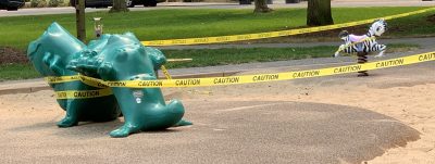
As Geri and I walked through Bubb Park, I tried to remember details I’d want to write about. The play structures were roped off with yellow caution tape and a sign said, “In an abundance of caution, we are closing the play structures.”
The “trail” through Bubb went beside a row of 3-4 redwood trees. They were on a mound. I was so eager for any kind of real hiking that I left the paved path and walked up the teeny ridge to the teeny hill and wound left and right around the redwoods. There wasn’t really any challenge, even for me, but I used my sticks anyway coming down. All I’d need would be to injure myself right at the start of a big project.
We left the park and walked along the street, passing the little cul de sac where once a week I pick up a box of organic farm fresh veggies from Full Belly Farm.
During the first part of the lockdown that sidewalk was rich with chalk hearts and roses, chalk people and waterfalls, letters in rainbow colors calling on us all to love each other and be safe. When George Floyd was murdered, the sidewalk art changed. “Say their names,” said big purple 3D letters, followed by a hundred feet of sidewalk with names in chalk of dozens of black people killed by white cops over the years.
Most amazing to me is that no fussy neighbor in that cul de sac had washed the names away. They’re still there today, somewhat faded but still readable.
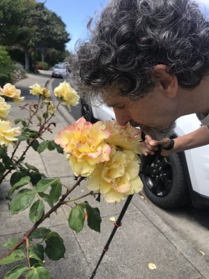
Our walk today was short, only about 4 blocks to Cuesta Park, our next destination. I leaned over to smell some roses: you only get half the experience of a rose if you don’t smell it! After my nose touched the rose I worried that someone with COVID may have sniffed the same rose, but it was too late to go back and not smell it.
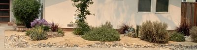
Lots of houses had traditional lawns and rose bushes but we saw several native plant gardens that were artistic arrangements of rocks, crystal granite, succulent aloe with spiky edges, luxuriant deergrass and native trees.
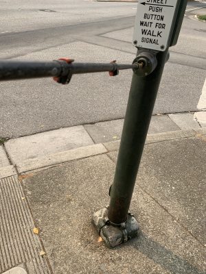
We reached 4-lane Cuesta Drive and a walk signal. How to press it in the age of COVID?
One small benefit of CMT. I lifted the tip of my walking stick and pressed the button with it. Geri nodded, grinning and I gave a salute and took a bow.
We crossed to Cuesta Park, our goal for this day. The park fills several city blocks and has walking trails, play structures (all closed) and a tennis court. Google Maps showed a tangle of trails on the north side of the park. These turned out to be a dog walking area.
We found a spot under a tree but couldn’t get six feet from the trail. We carefully arranged trash bags again for sitting on. I didn’t yet feel the need (and it wasn’t yet mandatory) to keep my mask on when there was nobody passing by but Geri kept hers on and if I went back there today, I would too.
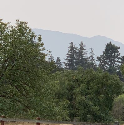
For the first time we had a view of the hills which we would eventually reach. Dark green and golden brown, they rose in folds. Rancho San Antonio, Montebello, Los Trancos and many other Open Spaces or County Parks, all were up there in those peaceful, hazy hills.
By good luck, we’d sat where we could barely see the city. Just trees and hazy hills and blue sky mottled with bands and puffs of cloud.
“If we just keep doing this hike, we’ll reach those hills,” I said happily. We gave each other a thumbs up.
As always, you should work with your doctor if you have CMT. More info on CMT here.
Places we went on this section: Bubb Park, Cuesta Park
Enjoyed your foray into nature and your vivid descriptions. Keep up the good work. It also helps having a wonderful mate by your side snapping photos along the way.
It does indeed! And a supportive Dad who encourages me.
Lovely stuff, Michael. As you know…. I know EXACTLY how you feel 🙂
I know you do! Thanks for reading and for the encouragement.